Quote of the day—PeacefulMountain

YOU DIDN’T MENTION THIS CACHE WAS DOWNRANGE OF A 3 DAY EXPLOSIVES FIREARM EVENT!

I was in Pullman on business this weekend and I made it my goal to find all the old caches in the area. I wasn’t planning on going for any caches today but when I realized I still had 2 hours of sunlight left in the day I made a run for this cache, and I was not prepared. I had only 1 primitive map downloaded, and no nearby caches.

But I insisted anyway, and I made it to the area just in time. When I turned down the paved road I discovered that there was event today, and I could practically drive straight up to GZ. But what’s with all these signs that say Boomershooot, and this line of gun stands? And what looks like a firing line. Turns out they were in the middle of a firearms and explosives event and the cache was downrange.

Luckily they were just all camping, drinking beer, and telling questionable stories about Seattle life.

I found the cache easily, and signed the log just as the sun was setting.

Thank you Joe Huffman for the cache!

PeacefulMountain
May 1, 2021
Via email from geocaching.com.
[I try to make my Geocaches a little more interesting than most.—Joe]

Open source maps on Garmin GPS?

I got a Garmin GPS for Christmas, a hand-held one ideal for backpacking. Pretty neat. But then I looked closer, and had a “what the hell?” moment. It has no topo maps. Not even regional low-res 100k maps. Nothing. A few political outlines, major roads, major water obstacles like Lake Washington. You have to buy topo maps as extras. I thought the whole point of a GPS was not to point at a spot in a blank area and say “you are here.” Heck, I can get that with pencil and paper, and know general direction with a compass.

So I went to the Garmin site. They want a hundred bucks for a Northwest 24k topo map. Another hundred for a CA/Nevada topo. Another hundred for “mountain west.” Another hundred for Alaska. Another hundred for 100k US. And so-on. Holy COW! If you get around much, you could easily spend far more on maps than on the GPS unit itself. The unit I received had been bought on sale; any two of those are more than the unit cost.

I dug around a little bit online, and there are some references to using open source (USGS, TIGER, or whatever) topo maps, but nothing very specific or detailed that seemed like the right path. Anyone know any good sourses for free open source 24k topo maps and directions for putting them onto Garmin handheld GPS units? If I can get pointed to some that look like they will work, I’ll try it and let readers know how it goes.

Do you believe in mermaids?

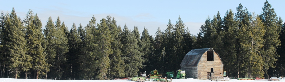
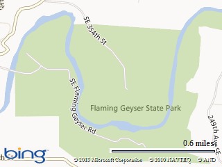
Today Barb L. and I went to Flaming Geyser State Park (Washington State). This was the “stomping grounds” of Ted Bundy and The Green River Killer. In fact the Green River runs right through the park:

Map picture

As we were entering the park I told Barb L. the story of when Barb S. her mom, and I came to the park about 30 years ago. Barb’s mom, Joy, used to tell the story of that visit. Some guy started talking to Barb and quickly left when Barb said that her husband was “just over there taking a nap”. Joy thought the guy was acting strange and she was very suspicious. She would point out that Barb S. looked a lot like the victims of Ted Bundy and her recollection of the guy at the park was consistent with Ted Bundy.

It was sort of a strange feeling as Barb L. and I pulled in and parked. There, just a couple hundred feet away, was “The Green River” so famous for all the women killed and dumped near or in it.

We shrugged off the feeling and found the trail to the flaming geyser. It’s not much. For a while when hole was drilled (coal exploration), back around 1900, the flame would be as high as five or six feet. Now it’s about five or six inches (see also the picture associated with this tweet):

IMG_6181Cropped2013

We found a geocache nearby. It was the first one I had looked for in a long time.

We then found the trail that went into the woods a couple hundred yards to the “bubbling geyser”. If you looked closely you could see bubbles coming up through the water. We hung around for a few minutes then some guy showed up on the trail above us with his dog and just stood there. I figured he was waiting for us to leave so I suggested we go because we really came for a hike, not to stand around and talk.

We hiked up the little hill to the trail where the guy and the dog were. The dog really wanted to approach us but the man had him on a leash and held him close. I slowly reached out my hand and let the dog sniff it. The guy started talking to us and told us a little about his dog. Then asked if we had been down the trail by the river to the Indian hieroglyphics. We told him no but that sounded interesting. He gave us directions then asked, “Do you believe in mermaids?” We smiled, and said no. He then started telling us stories about Indian paintings of people with big fins for feet and a hand coming out of fisherman’s nets and taking a swipe at the fisherman. “I believe”, he told us. As Barb and I started edging on down the trail he started talking about the UFOs (see also this tweet).

We strolled on down the trail in the direction of where the hieroglyphics might be. The guy and his dog passed us and disappeared on ahead. We found the trail near the river and followed it for a while in the proper direction until it petered out in thick brush and trees. We decided we weren’t so interested that we wanted to push through the brush. Then the voice of Mermaid Believer came to us, invisible through the brush ahead of us, “The river’s too high. You can’t get there easily now.”

Okay then. Time to head back out. We walked back toward the picnic area with Barb checking to make sure she had her knife with her. I told her, “And you know how to use my gun if need be and I’m not able to do so.”

We went back to the picnic area and there was Mermaid Believer again. He was a couple hundred feet away on the other side of the picnic area moving parallel to us. We went back to the car and I got out my telephoto lens and camera and managed to take just one picture of him before he ducked behind what we believe was his vehicle:

IMG_6197Cropped
That was interesting.

We found another trail and went on up the trail with Barb telling me “women raped and killed while hiking in the woods” stories from the knife class she took last weekend.

Our trail made a loop and we arrived back in the picnic area 20 or 30 minutes later. Mermaid Believer, his dog, and his pickup were gone.

I have just one question for you… “Do you believe in mermaids?”

Geocaching could get you arrested

I heard it on the radio yesterday while reloading ammo.  It’s on the web now:

Idaho 55 at the Rainbow Bridge was closed for about six hours Tuesday after a suspicious object was found underneath the bridge.

An ITD spokesman said investigators were conducting a routine bridge safety inspection around 9:30 a.m. today when they saw an object they could not identify. It was a green bucket with wires poking out.

Idaho State Police and the Boise Bomb Squad were called in to investigate and 17 miles of highway was closed. Investigators determined the bucket was filled with trinkets, photos and toys placed there as part of an online scavenger hunt called geocache. Players use a global positioning system to find the treasure.

Police say the man who stashed the object under the bridge has come forward and charges might be filed against him.

As it was said in a geocaching forum:

Consider. If all it takes to shut down the country is to toss ducted tape tupperware full of rocks with an old radio in it out the side of your window while you are driving down the interstate, then it won’t be long before terrorists start causing disruption in a mass scale by doing exactly that.

There are an almost infinite number of things we can’t and shouldn’t defend against.  Money is better spend attacking the root of the problem–extremist Muslims.  We must destroy their culture.

Anniversary weekend

About 18:30 on August 19th (Friday night) Barb and I decided to go to the B-23 bomber that crash landed on Loon Lake and slid into the forest in 1943 for our 29th wedding anniversary.  We threw some stuff in the Jeep and drove to Riggins expecting to find a motel in either Whitebird or Riggins.  There were none.  The fire fighters had taken what the tourist hadn’t.  We ended up finding an open spot in a campground just off the Salmon river about 12:30 AM on Saturday morning and slept in the Jeep.  After waking at about 6:30 we drove about 50 miles, mostly on one-lane roads, to Chinook campground.  We hiked ten miles round trip from Chinook Campground to the crash site and back to replace a missing geocache (B-23).  Barb had not been there before and was very impressed with the site.  The pictures are here.

On the way out we figured we should go through McCall to improve our chances of finding a motel.  We arrived back at the Jeep about 18:00 tired and sore.  From the Chinook Campground it took us only an hour to reach McCall. Again, the motels were all full except for a luxury suite for $225/night.  We drove to New Meadows.  Again, all full.  We called several motels in Grangeville.  Again, all full.  We drove north, dirty, tired, and getting hungry.  At Pinehurst we found a motel with a Vacancy sign.  We rang the bell and waited, and waited.  Finally a man appeared to tell us his “No” sign was broken.  We drove to Riggins and found a motel with two rooms available.  We were thrilled!  We showered and went to dinner.  It was about 20:40 when we walked into the restaurant.  Except for the cook and the waitress we had the place entirely to ourselves.  Riggins appears to close up early on Saturday nights.  It was great food and we went to bed tired and very happy.  It was a great day in the woods and one of our best anniversaries yet.

Enabling an old geocache

One of the first geocaches in the Moscow (Idaho) area was this one which I placed March 11, 2001.  A fire on September 8, 2001 destroyed it.  I replaced it on April 4, 2002.  Then the location went under new managment and no trespassing signs were put up (unrelated to geocaching).  Barb and I moved it a few months ago but I just now got around to getting good coordinates, a picture, and reactivating it.  It used to be called “Stumpy” but I renamed it “Rocky” in the new location.  Here are current pictures of the cache:


In the ammo can under the rock.


“Rocky” from a few feet away.