Emily Miller is asking for pictures of ordinary people with their guns. It’s for a book.
Category Archives: Gun Fun
Gun Song- Kaylee Rutland – Daddy’s got a .45
Current country rock chick Kaylee Rutland has a song about a classic sort of situation – dad making sure his little girl is properly treated, and the guys that come a’court’n are worthy of their pride and joy. Cute, fairly predictable, fun.
Field Ballistics is available on Windows Phone
I just received notification that Field Ballistics for Windows Phone has passed the Microsoft certification tests and is now available in the store. It may take a day or two before you can search for it in the store but you can install it now using this link.
Some of the cool features are illustrated with the following screen shots:

The shooter and targets are placed on a map. The program automatically computes the range to the targets. It also automatically computes the direction of the wind relative to the bullet flight path. This means that if the wind is from the west and you are shooting at a target to the south you will get the correction the full value of wind drift. But if you then choose a target directly east (or west) of you the wind correction will be zero. Of course all the trigonometry is done to correct for shooting in all directions.
At the bottom of the screen are two columns. The left column is the ballistics solution to make the shot at the selected target. In the right column is data about the target and the bullet when it arrives at that target. Of particular note is that in the case above the bullet velocity is in red (the theme color of the phone). This means the bullet velocity is below the minimum you have specified in the settings. This is particularly important for Boomershooters because the targets won’t detonate if the bullets are going too slow.
Tapping the ‘S’ or ‘T’ icons at the bottom of the screen moves the center of the map to the shooter or the selected target. The down arrow icon moves the selected target (or the shooter if it was selected) to the location of the phone using the phone GPS. This means that you can set up multiple targets on the map, then the shooter can “run and gun” and get ballistic solutions quickly. By using the GPS to get the current location of the shooter the distances and wind corrections are automatically update for each position the shooter wishes to shoot from.

You can add as many targets as you wish* and give them user friendly names. If you tap the “Measure” button you can use the phone camera and accelerometer to determine the incline to the target from your current location.

This is the incline measurement screen using the camera. You put the crosshairs on the target and tap “Done” to capture the incline of the phone for this target. You can also zoom in or out and refocus the camera.
[Please note this is only to illustrate the incline measurement feature, not to advocate shooting in cities.]

The automatic weather conditions are obtained from the current location of the shooter. This doesn’t mean the physical location of the phone. You can position the shooter in another state and the nearest weather station to the designated shooter location will be used. When you define your own conditions you can even use the phone GPS to capture your altitude.

Black Hills and Federal match ammo are predefined. Add as many of your own cartridges* as you desire.

Some predefined rifles are included but you can add as many of your own rifles* as desired.

There are pages and pages of easily accessible help on the phone.
*The trial version only allows one target and one each of user defined conditions, cartridges, and rifles.
Field Ballistics failed certification testing
This afternoon I received an email from Microsoft telling me my new phone app failed the certification testing.
There were two errors. In the first case I didn’t have a clue I was violating the policy. In the second case I was careless. Both are easily fixed.
Test failure 1:
Test: Content that is offensive in any country/region to which your app is targeted is not allowed. Content may be considered offensive in certain countries/regions because of local laws or cultural norms. Examples of potentially offensive content in certain countries/regions include, but are not limited to, the following:
Group 1: China
Prohibited Sexual Content
Disputed territory or region references
Providing or enabling access to content or services that are illegal under applicable local lawComments: Result: Fail
Your application uses the Bing Maps Silverlight Control for Windows Phone. Bing Maps is not supported for Group 1 countries at this time. You may resubmit your application and deselect the Group 1 countries.
Test failure 2:
Test: Screenshots must only contain app graphics, and must not include any emulator chrome, frame rate counters or debug information.
Comments: The application screenshots contain frame rate counters and debug information.
Three out of the eight screenshots had the frame rate counters and debug information in them. I knew better and just wasn’t paying close enough attention in my rush to get the app submitted.
It will take 30 minutes or so to fix it and resubmit. I’ll get to that sometime tonight after visiting my son and his family.
Gun Song – Fred Eaglesmith – Time to get a gun
Field Ballistics for Windows Phone
I just submitted my exterior ballistics app, Field Ballistics, to the Microsoft store for Windows Phone. It will be a few days until it is published. In a day or so I’ll give more details but here is some of what I submitted:
Field Ballistics is a revolutionary exterior ballistics application. Previous ballistics app are little more than glorified pieces of paper with ballistic tables. Field Ballistics uses the phones high tech capabilities to give ballistic solutions for multiple targets.
Place push pins on a map for each target automatically computing the distance from shooter to target, use the camera and accelerometer to measure the incline, use the Internet to automatically get up to date environmental conditions from the closest weather station. Select a target on the map and see the exact scope settings needed and information such as the time of flight and bullet velocity at impact.
When the shooter moves to a new location the ballistic solution for each target is automatically updated. Range and wind direction are automatically corrected using the new shooter location and information from the nearest weather station. You just enter in the new scope settings and take the shot.
Select from any of Federal or BlackHills match ammo or add your own. Input chronograph velocities and Field Ballistics corrects for the distance from the chronograph to the muzzle.
Field Ballistics is more than a glorified piece of paper. It uses the full power of your phone to give you ballistic solutions to multi-target problems.


I started seriously working on this about a year and a half ago. It feels really good to get it out the door.
Update:
In response to this comment from Ray what follows is the exact text of the privacy policy stated in the app:
Requests for map and location information from Bing and other Microsoft services are made by this application and may include the current location of your device. This application uses the Microsoft location service for some actions.
These actions will cause the location of your device to be stored on the device. This information, and all other data for this app, can be deleted by using the ‘reset’ menu item. The use of the location services can be disabled by using the ‘disable use of location services’ menu item.
If ‘Auto’ shooting conditions are used then requests for current weather conditions at the shooters location are made from wunderground.com.
Other than as disclosed above, no information of any type is ever sent by this application to any other device, user, application, or web site for any purpose.
Interesting, but not quite there
InteliScope has an interesting product:

The further say:
The on-screen, heads-up display of the Inteliscope app is packed with features including:
- Intuitive User Interface
- Custom Crosshairs
- 5X Digital Zoom
- Video Recording from the Shooter’s Perspective
- Ballistics and Firearm Data
- Built-in Compass
- GPS Position
- Local Prevailing Winds
- Shot Timer
- Flashlight and Strobe using Built-in LED
This device is limited by camera optics and is intended for short range tactical use.
…
Not recommended for calibers larger than .223 or 5.56mm.
You are supposed to use your iPhone directly as a sighting system?
Am I overlooking something here?
Sorry. I don’t think it is going to work that well for the following reasons:
- Display brightness: With direct sunlight on the display you aren’t going to be able to see any detail, and maybe not anything at all.
- Repeatability of the mount and even the camera stability inside the iPhone case is going to make it a 5 or 10 MOA system.
- At short ranges, a limitation they admit, wind and ballistic calculations are so minimal that the repeatability of the mount is going to be the dominant factor. So you haven’t gained anything with the computing power you are bringing to the party.
- Battery life: How long is your battery good for when you have the camera and CPU running?
I think it would be better if you could connect the camera through a real scope that won’t have the problems with repeatability and you get long range capability. You still have problems with bright backlighting but you have addressed two out of the three big issues.
Okay. It would be cool to have video of the target as you hit them but you can get that with something like GoPro or video glasses while using a real sighting system.
Gun Song – Shotgun – Lightnin’ Hopkins
Classic old blues song. Kind’a sad, simple, tells a story. A twist at the end that a lot of modern rappers could learn from. Enjoy, or at least have a listen.
Lightnin’ came in at #71 of all time great guitarists on Rolling Stone’s list. Blues are not normally not my favorite genre of music, but there are some gems out there.
Gun Song – Six String Gun – Sean de Burca
Someone I’d never heard of, sort of the other end of the spectrum from the Beatles or Ernie Ford. Interesting style. Decent acoustic guitar.
If you want to know more about him and his music, http://seandeburca.wordpress.com/ would seem to be the place to start. As always, all honest thoughts welcome.
Gun Song – Cleaning My Gun – Mark Knopfler
Master guitarist. Another song I wasn’t familiar with until I found it. Thanks for the recommendation, John V.
Mark Knopfler has been playing the six-string for a while, and is generally considered one of the greats of the instrument.
Speaking of serious guitar stuff, a news story just came out that makes the Gibson guitar make raid make sense, in a “Chicago Thug Methods” sort of way.
Boomershoot 2014 entries
Boomershoot 2014 entry is now open for staff. If you were staff for 2013 and use the same exact spelling for your name as before the entry software will allow you to enter now.
If you were a participant in Boomershoot 2013 then the software will allow you to enter tomorrow, Wednesday May 22, after 6:00 PM PDT.
Anyone is allowed to enter after Friday May 24 6:00 PM PDT.
There may be some web service interruptions. My web hosting provider is updating my server and it will involve a change in IP address. If you get a page not found type error wait an hour or so and try again.
Gun Song – Marty Robbins – Big Iron
I’m finding all sorts of interesting things in a quest to find a gun-song per week. Here is Marty Robbins song “Big Iron” (on his hip). Simple tune, clear vocals, good story. It sounds like the background guitar player is having fun trying to slip a little fast-n-fancier stuff into the short spaces left in the vocals. What’s not to like? Sort of an antidote to a Beatles take on guns.
Marty Robbins is sort of in the same genre as “Tennessee” Ernie Ford, singing gospel, country, early rock, etc. Good stuff.
If any of you have suggestions, I’d be happy to consider them. Got another seven queued up, keep us in Friday tunes until the 4th of July.
First shots
For some reason I put together another AR. I’ve had a pretty nice Colt’s Match HBAR for years, but I thought a light carbine would be good to have around for kids, new shooters and such. My daughter might want it at some stage.
This new one is cobbled together from nearly as disparate a set of parts as is possible. I think every parts group is made by a different company. The aluminum, railed gas block, for example, was knocked out on an old Bridgeport mill by Some Dude in Moscow, Idaho– I had to mount it on the lathe and trim it down a bit to make it clear the floating handguard, which is a used piece off of Some Other Dude’s AR. It’s all assembled as a mock-up right now. Mostly new parts, some of the metal being in the white. I wanted to proof test it before taking it all apart again, bead blasting it and giving it a finish of some kind.
Since none of the working parts had ever fired a cartrige before, I cranked off four rounds with the carbine held at arm’s length, one-handed, into a hillside (the thought had come to mind that the thing could blow up, and if it was going to do that I wanted it to happen far away from my face). Perfect function. All ejected cases ended up in a nice tight group off to my right, too.
After putting a few shots on paper at 25 yards, I took it out to 100 to get a good zero on the TX30 reflex sight. Here’s the 100 yard target. I fire two-shot groups for initial sight-in. One-shot “groups” would probably be OK for starters, but I like to get some sense of how I and the rifle are working together. The first 100 yard group is the one holer at the top of the paper, on the “1L” line. I’d thought that the TX30 had 1/3 MOA clicks like an ACOG telescope, so I over-compensated, putting the second group near the bottom of the paper. The TX30 has 1/2 MOA clicks, and the fact that the target was stapled to a log and was slanting back quite a bit accounts for the larger apparent error. Splitting the difference with a few “up” clicks, and a couple clicks left, the third group was pretty well dead on;
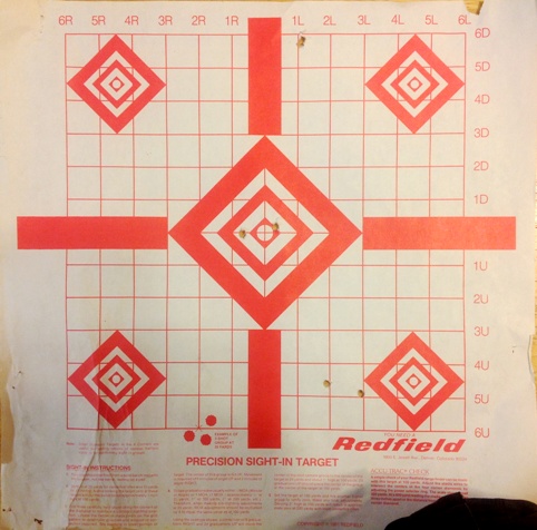
I have a padded steel rifle rest and some shooting bags, but I’m using them less and less. If you can’t use your vehicle, a stump, a tree branch, a rock, the ground or your knee, what kind of shooting are you practicing? In this case I was mono-podding, holding the 30 round magazine in my hand and resting the hand on the hood of the pickup. It works well enough. The truck bumper is OK too, or the tail gate, or a front tire steered over to one side. The tip of a longish snowshoe can make a decent place to rest your knee in a kneeling position… There are lots of options, so you can haul around less stuff.
Three consecutive two-shot groups of around 1 MOA and less. I be happy for now. Don’t ask me to repeat it. It was getting dark so I called it a day and let the dog out to romp around for a bit and get wet and smelly before the ride home. Ultimately I think I’ll want a solid 200 yard zero for this reflex-sighted carbine.
Dealing with “issues” while shooting is a good thing. In this case it was failing light, mosquitoes, my dog which hates gunfire (he ended up inside the pickup, and his moving around made the pickup, which I was using as a shooting rest, move just a little bit while aiming) and the fact that I’d ended up out there with no spotting optic so I had to trot the 100 yards back and forth to determine shot placement. That and there were people driving up and down the road, which was close enough I didn’t want to fire while people were so close and make them nervous. So I’m looking around, listening, swatting bugs, dealing with the dog, hurrying, and huffing and puffing a little. It’s an exercise in being very still while immersed in little stresses and distractions. That’s part of why I like rifle shooting so much. It’s wonderful. Sometimes it works out great and other times you chalk it up to learning. This time was like a dream, but I’ll have to figure out what happened to my 20×60 binocs.
This new light carbine is pounds lighter than my scoped HBAR rifle. I think it’s going to be one of my favorite shooters. I’d never “built” an AR before, and even though I’d had my Colt, and a Rock River, apart many times it was surprising to me how easy it was to cobble one together from parts. A fairly small child could do it, with a little bit of instruction.
Gun Song – Happiness is a warm gun – The Beatles (?!)
I came across a Beatles song I’d never even HEARD of before. A gun song from The BEATLES?! Happiness is a Warm Gun, from the White Album. Hmmm… Looking at the lyrics, it’s clear they were pretty clueless about what they were singing about. Of course, being as it was released in 1968, perhaps not so surprising. There were a LOT of things done then in popular culture that made people say a all kinds of seriously weird and disjointed stuff. Can’t say they are not musically talented, and on a technical basis interesting. Also can’t say it’s a very good song as a song, IMHO, but here it is to you to make your own opinion of.
Hopefully, no-one needs much of an intro to the Beatles, but for the younger crowd, that was who Paul McCartney played with before Wings. For the whipper-snappers who don’t get that joke, never mind, just look them up.
Random thought of the day
Ry stopped by my office this afternoon and shared this bit of knowledge with me:
When you are shooting into a fire a red dot sight is totally worthless.
It’s obvious in hindsight but neither he nor I thought of it ahead of time.
Gun Song – Tchaikovsky – 1812 Overture (with cannons)
No “gun” in the title, but anything that is actually performed with real cannons certainly qualifies as a gun song. The exciting part is near the end, for those not familiar with it. It’s a famously rousing piece, at least the ending. The rest has a narrower appeal.
Tchaikovsky is one of the big names in classical music. He was Russian, born in 1840. If you like classical music, you likely know about him, or at least OF him, and if you don’t, nothing I say will change your mind, most likely. But an interesting factoid was that he made an appearance at the inauguration of Carnegie Hall.
Stuff I didn’t know
Double action, pre Civil War design percussion revolver. It has a fully enclosed cylinder, i.e. a top strap. What I don’t get at the moment is why there are twice as many cylinder notches as there are chambers.
This is the sort of thing I’d like to own, and yet I can give no practical reason for it whatsoever.
ETA; I think I figured out the cylinder notch thing. It must be a safety system. Colt’s, Remington and others had similar features, pins or notches in the back of the cylinder to engage the hammer, that more or less locked the cylinder half way between chambers, so the hammer could rest safely between chambers, allowing the carrier to have all chambers loaded rather than resting the hammer on an empty chamber. This revolver is simply using the existing bolt (cylinder lock) for that purpose, methinks, hence the “in between” cylinder notches.
Quote of the day—Max L.
It was totally worth it.
Max L.
April 26, 2013
After completing the Boomershoot High Intensity Event.
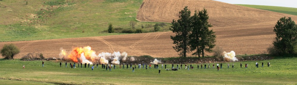
[Max had spent the day working in a crowded hot shipping container helping to make reactive targets. A few minutes of Boomershoot therapy was apparently compensation enough.
Video and pictures in a day or three.—Joe]
Gun Song – Dana Lyons – Cows With Guns
What can I say. A classic. With animations.
Hope to see some of you at Boomershoot.
New shooter smile
Via email from Will:

It was taken at the Norpoint range in Arlington WA.
And that is part of why we win.